

More than a decade before the Texas Revolution, Stephen F. Austin’s colony was fighting a violent frontier conflict just west of present-day Houston and Katy, Texas. During the 1820s, settlers clashed with Karankawa, Tonkawa and other Native American groups across the Brazos and Colorado river settlements. Raids, horse thefts, killings and retaliatory attacks swept through Mexican Texas. Stephen F. Austin governed with a hands-on approach, personally leading armed expeditions, organizing some of Texas’ earliest Rangers and eventually waging a campaign against the Karankawa. Much of this forgotten conflict unfolded around San Felipe de Austin, his colonial capital only about 20 miles west of modern-day Katy.
John C. Alley and two companions were paddling up the Colorado River in late 1822 or early 1823 when a Karankawa party attacked their canoe near the mouth of Skull Creek. Alley and one of the other men were killed. John C. Clark escaped. The same party later attacked Robert Brotherton and left him severely wounded.
The colonists answered with an attack of their own. Robert H. Kuykendall gathered a group of armed settlers, followed the Karankawa trail and struck their camp near Skull Creek. Later reminiscences say the Karankawa suffered heavy losses, although no reliable casualty count survives.

By the summer of 1823, the violence had reached the colony’s young government. John Jackson Tumlinson Sr., the first alcalde of the Colorado District, was responsible for both local administration and the militia. In July, he left for San Antonio to consult the Mexican governor about the killings and thefts plaguing the settlements. Native attackers killed him during the journey. His companion, known in the surviving record only as Mr. Newman, escaped, but Tumlinson’s body was never recovered.
On Aug. 5, Austin announced that he would employ 10 additional men “to act as rangers for the common defense.” Each man would receive $15 a month, payable in property, and furnish his own equipment. The Texas Ranger Hall of Fame and Museum traces the Rangers’ beginnings to these small mounted companies. The Texas provisional government formally established a Ranger force in 1835.
Austin took the field himself two months later. One Tonkawa group had stolen valuable horses from the Brazos settlements. Another had gone downriver through a district of isolated farms, demanding corn and threatening residents. On Oct. 2, Austin led armed men to the Tonkawa camp, surprised its occupants and recovered the horses. He compelled the chief to have the accused men whipped, ordered the group away from the Brazos and Colorado rivers and warned that another theft could end with the offenders being shot.
Austin recorded the confrontation 18 days later in a letter to Lt. Col. Luciano García, who had recently served as interim governor of Mexican Texas. His account survives in The Austin Papers, the collection of his personal and official correspondence edited by historian Eugene C. Barker.
The killings, pursuits and militia orders spread across the Brazos and Colorado settlements and the coastal prairie. Austin’s colony soon centered at San Felipe, which now lies about 20 miles west of Katy. Families lived miles apart, travel followed rivers and rough trails, and Mexican soldiers were too distant to answer every report of stolen horses, threats or bloodshed.
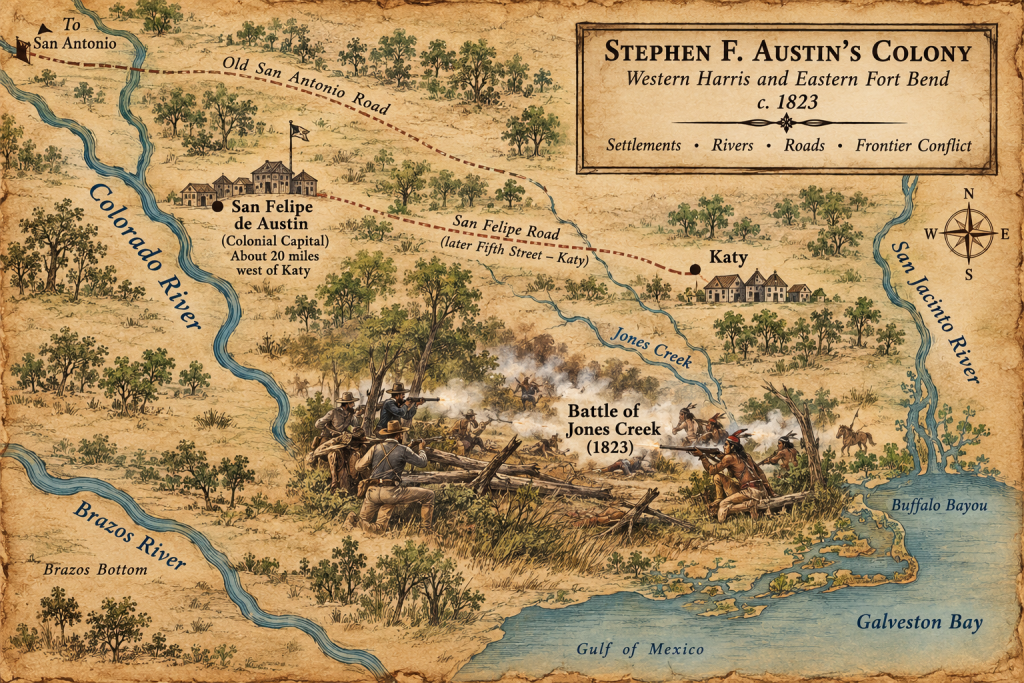
A Mexican Colony Near Present-Day Katy
Texas still belonged to Mexico. San Antonio served as the seat of provincial government, and the United States ended at the Sabine River. The Republic of Texas would be declared 13 years later. Houston would be founded in 1836, and Katy would not be platted until 1895.
Mexico had won independence from Spain only two years earlier. The 11-year war had damaged farms, mines and trade and depopulated entire districts. Texas had also been the scene of a failed revolt against Spanish rule. In 1813, the republican army that captured San Antonio was destroyed at the Battle of Medina, the bloodiest battle ever fought on Texas soil.
Stephen F. Austin was 29 years old when the fighting at Skull Creek occurred. He had worked as a businessman, served in the Missouri territorial legislature and briefly held a judgeship in Arkansas. His father, Moses Austin, had received Spanish permission in January 1821 to bring 300 families to Texas but died before he could carry out the plan. Stephen traveled to San Antonio and then Mexico City, seeking approval from a succession of governments as Mexico passed from Spanish rule to an empire and then toward a federal republic.
Emperor Agustín de Iturbide signed the colonization law supporting Austin’s project in January 1823 and abdicated in March. Mexico’s provisional government upheld Austin’s contract the following month. The political instability of Mexican Texas left the province with little money, few troops and long distances between its scattered settlements.
Austin’s title was empresario, a colonization agent responsible for recruiting settlers and overseeing their land grants. Mexico also entrusted him with extraordinary governing power. According to the Handbook of Texas, Austin exercised civil and military authority over his colonists until 1828, under nominal supervision from officials in San Antonio and Monterrey. He wrote legal forms, established a basic civil and criminal code, supervised local officials and served as a lieutenant colonel of militia who could organize and lead armed campaigns.
By October 1823, Austin and land commissioner Baron de Bastrop had selected a high bluff above the Brazos for the colony’s headquarters. San Felipe de Austin stood near an established river crossing and occupied a central position in a colony stretching from the Lavaca River to the San Jacinto and from the Gulf of Mexico north to the Old San Antonio Road. The territory included part of the country now occupied by greater Houston and the river settlements that later became Fort Bend County.
Modern Katy still carries a trace of that geography. Fifth Street follows the old San Felipe Road, which opened to Austin’s colony during the 1820s, as Katy Christian Magazine’s history of Cane Island and the lost communities around Katy explains. The road connected the prairie east of the Brazos with the colonial capital at San Felipe.
A Colony Built Across Native Homelands
The people remembered as the Old Three Hundred were actually 297 grantees who received 307 titles. They selected rich bottomland along the Brazos, Colorado and San Bernard rivers, from the Gulf north toward present-day Brenham, Navasota and La Grange. A farming family could receive about 177 acres; a family classified as ranchers could obtain about 4,428 acres. Many immigrants came from the American South, and some brought enslaved people whose labor would support the colony’s developing plantation economy.
The grants converted land into surveyed private property in a country that was already inhabited and used. The name Karankawa refers to several related coastal peoples, including the Carancahuas, Coapites, Cocos, Cujanes and Copanes, who shared a language and culture. Their homeland stretched along the Texas Gulf Coast from Galveston Bay toward Corpus Christi Bay. Families moved seasonally between barrier islands and the mainland, traveling in dugout canoes and following fish, shellfish, game and plant foods. River mouths and coastal bays that attracted Austin’s settlers were essential to Karankawa life.
The Tonkawa were an association of independent bands whose range centered farther inland. They traded with the colonists, stole horses from them, fought them and later joined Texans against the Comanche. Waco raiding parties, belonging to the larger Wichita cultural world, sometimes traveled down the Brazos from villages near present-day Waco. Comanche pressure lay farther west; the principal confrontations around San Felipe and the lower Colorado involved other Native peoples.
Austin Orders the Militia South

In December 1823, Austin ordered settlers living from Eagle Lake down the Colorado toward the Gulf to organize as a militia detachment. The order said families in that corridor were exposed to Karankawa hostilities. The officer in command could call armed men into service and pursue Karankawa parties found along the river or coast.
The geography made the danger difficult to contain. Eagle Lake lies southwest of modern Katy, while the Colorado continues through the coastal prairie to Matagorda Bay. Farms and cabins occupied stretches of river separated by timber, prairie and miles of rough travel. An attack near the coast could prompt militia movements far upriver; a report reaching San Felipe might already be days old.
On April 20, 1824, Austin wrote to the Mexican military commandant about two colonists who encountered Karankawa people while hunting deer near the mouth of the Colorado and escaped. Settlers later found a camp containing property that Austin said had been taken the previous year. He also reported that Karankawa fighters had killed inhabitants and destroyed a settlement near the river’s mouth.
Austin told a Karankawa chief to keep his people away from the Colorado and Brazos until peace could be arranged because colonists wanted revenge for those who had been killed. Four months earlier, he had authorized the militia to pursue or attack Karankawa parties found along the river or coast.
The Battle of Jones Creek
Fighting erupted again along the lower Brazos in June 1824. According to the Texas State Historical Association’s account of the Battle of Jones Creek, the immediate trouble began at a store owned by James “Brit” Bailey, an irascible early settler who lived near the river. Karankawa men sought to purchase ammunition. Fighting broke out, and the Karankawa withdrew toward their camp.
Austin commissioned Randal Jones and 23 other settlers to mount a retaliatory expedition after raids in which immigrants had reportedly been killed. Jones was already experienced in frontier fighting and had worked as a trader in Nacogdoches. On June 22, his company encountered approximately 30 Karankawa camped beside the stream that later took his name in southern Brazoria County.
The settlers attacked the following morning. Both sides suffered substantial casualties. The surviving Karankawa crossed the San Bernard River, Jones’s company returned to the settlements and more fighting followed.
Jones soon acquired a direct connection to Fort Bend County. On July 15, 1824, he received title to a league and a labor of land in what became Wharton and Fort Bend counties. He settled on Jones Creek about 2 miles above present-day Richmond, later served in Austin’s municipal government and represented Fort Bend County during the Consultation of 1835.
Austin’s policy toward the Karankawa hardened during this period. The revised Handbook of Texas history of the Karankawa states that he came to regard extermination as the answer and personally led another expedition in 1824. The pressure drove Karankawa bands toward La Bahía, the Spanish and Mexican settlement at present-day Goliad. A priest there helped negotiate an armistice under which Chief Antonito’s people agreed to remain west of the Lavaca River.
The armistice protected Austin’s settlements by excluding Karankawa families from a large part of their traditional range. Continued immigration brought more farms, livestock and roads into the river bottoms and coastal areas on which those families depended. Austin’s colonists emerged with control over land the Karankawa had used for generations.
How Close Was the Frontier to Today’s Katy, Texas?
San Felipe stands on the west bank of the Brazos just beyond the present-day Fort Bend and Waller county line. Austin chose the site for its high bluff, fresh water and defensible position. By the end of the decade, it contained stores, taverns, a hotel, a blacksmith shop and about 40 or 50 log cabins. The land office operated there, mail routes converged there and Austin directed the colony from a cabin near the river.
When violence threatened outlying settlements, San Felipe served as the place where reports arrived, orders were written and frightened families could seek refuge. The history of Austin County records punitive expeditions against the Tonkawa in 1823, the Karankawa in 1823 and 1824, and Waco raiders in 1829. Residents west of San Felipe continued to abandon exposed homes periodically and retreat toward town until the Texas Revolution.
By 1836, Native raids in the immediate San Felipe vicinity had nearly ceased. Three years later, raiders stole several horses from homesteads along Mill Creek. The 1839 theft is the last recorded Indian raid within the boundaries of present-day Austin County.
By the time raids around San Felipe subsided, Native people had been killed, expelled or pushed toward other regions as the immigrant population multiplied. The Karankawa survived years of warfare, dispossession and later claims that they had become extinct; descendants organized as Karankawa Kadla continue preserving their history and language today. Tonkawa people endured removal to Indian Territory and are now represented by the federally recognized Tonkawa Tribe of Oklahoma.
Austin’s temporary companies became part of the Texas Ranger tradition. San Felipe grew into the colony’s political and commercial center, and its wide jurisdiction supplied the framework from which later municipalities and counties, including Fort Bend County, were formed. People such as Randal Jones carried their frontier military authority into the civil government of those new communities.
Katy developed much later as a railroad and rice-farming town, a local history explored in Katy Christian Magazine’s account of the 1900 hurricane that nearly destroyed it and its guide to lost communities around Katy. Long before railroads and highways, rivers, Native paths and rough roads determined how people moved through this country.
From Katy, the drive to San Felipe is shorter than many weekday trips across Houston. The San Felipe de Austin State Historic Site occupies the bluff where Austin placed his colonial headquarters beside the Brazos. Austin’s surviving correspondence describes widely separated farms, Native camps and travel routes, missing horses, militia orders and families ready to leave exposed homes for the security of San Felipe. The frontier in those documents begins about 20 miles west of Katy.
Enjoyed this article? Continue exploring the overlooked people, places and events that shaped Katy, Greater Houston and Texas in Katy Christian Magazine’s history archive. Read more from our Forgotten Histories series:
- The 1900 Galveston Hurricane Nearly Wiped Katy, Texas Off the Map
- Before There Was Katy: 10 Ghost Towns and Lost Communities You Never Knew Existed
- The Battle of Medina: The Bloodiest Battle in Texas History, Yet Most Texans Have Never Heard of It
- The 10 Greatest Lost Treasures in Texas: Spanish Gold, Pirate Treasure, Buried Silver and Hidden Fortunes
- Is Patterson Road Really Haunted? The Truth Behind Houston’s Most Haunted Road
- The New London School Explosion: The Deadliest School Disaster in American History Happened in Texas
- The Great Hangings at Gainesville: Texas’ Darkest Chapter and the Largest Mass Hanging in American History
- Before Jack the Ripper: The Servant Girl Annihilator Who Terrorized Austin, Texas
- The Nueces Massacre of 1862: The Forgotten Texas Civil War Tragedy
- Six Years After the Alamo, Mexico Invaded Texas Again and Captured San Antonio Twice