
Search for ghost towns near Katy, Texas, and you might picture an abandoned Main Street somewhere in far West Texas: a sunburned hotel, a leaning saloon or a vacant cemetery overgrown with weeds and draped in cobwebs, long forgotten by the world.
As it turns out, West Houston’s ghosts are harder to see.
They are buried under reservoirs, hidden behind office parks and preserved in names people repeat daily while unaware of their origins. Before Katy became one of the fastest-growing suburban areas in Texas, the prairie around it was dotted with railroad stops, farming settlements, churches, schools, post offices and small communities that were once expected to last.
But these historic towns near Katy vanished. Some were swallowed whole. Others survived only as a road name, a cemetery, or a marker beside a highway.

This is the second installment in a new Katy Christian Magazine series on the forgotten histories of Katy and West Houston: the places, people and stories that shaped the area long before today’s neighborhoods appeared.
Not every place on this list is a ghost town in the strictest sense. Some of these forgotten towns in Texas are better described as lost communities, faded railroad stops or historic settlements that were absorbed into Houston’s westward growth. But together, they tell a story many longtime residents have never heard: Katy did not develop from empty land. It rose from a prairie already full of names, vacated pitstops and ghost towns.
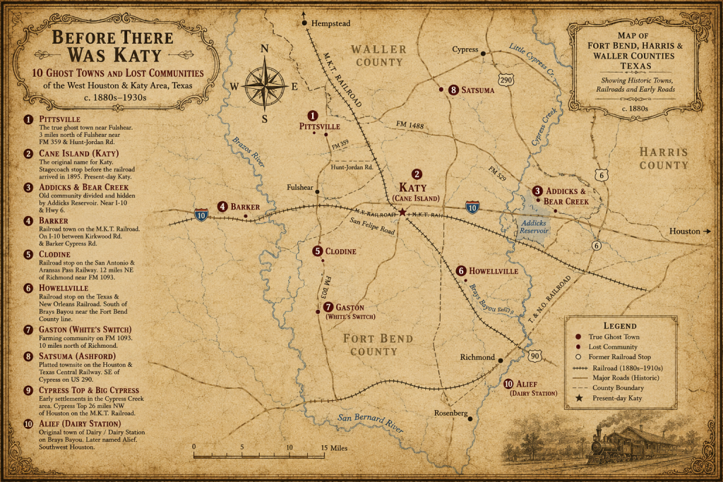
1. Pittsville: The True Ghost Town Near Katy
If one place near Katy earns the true “ghost town” label, it is Pittsville.
The former settlement stood three miles north of Fulshear near what is now Farm Road 359 and Hunt-Jordan Road in north Fort Bend County. According to the Texas State Historical Association’s entry on Pittsville, the community began growing when early plantation owners moved away from the swampier Brazos River bottoms and built homes on higher prairie land less threatened by flooding.
Pittsville was no tiny crossroads with two cabins. In 1860, the census listed about 240 people there, a meaningful number for that time. The community had farmers and stock raisers, but also wagoners, carpenters, schoolteachers, a brick mason, an engineer, a minister, a merchant, a physician, a wheelwright, a machinist and other tradesmen. Over time, Pittsville had several general stores, a blacksmith shop, a millinery shop, a photo studio and a two-story school or academy.
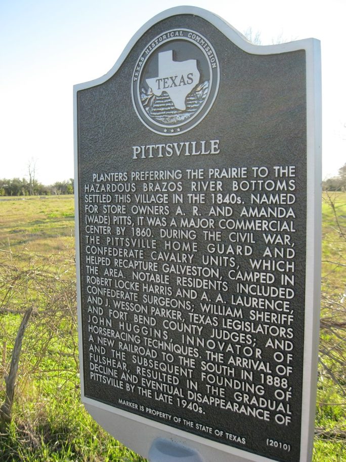
Photo: Texas State Historical Marker at the site of Pittsville. The marker is on the west side of FM 359 north of Fulshear. Djmaschek, CC BY-SA 3.0 <https://creativecommons.org/licenses/by-sa/3.0>, via Wikimedia Commons
But then, the railroad changed everything.
Pittsville’s post office opened in 1870, but the community’s future weakened after the San Antonio and Aransas Pass Railroad was built through nearby Fulshear instead of Pittsville. In an era when rail access could determine whether a town grew or declined, people and businesses began moving closer to the tracks. Pittsville’s post office closed in 1889, and the last residents left in 1947. After that, TSHA recorded that the only visible evidence left of the community was “an abandoned cistern and a clump of trees.”
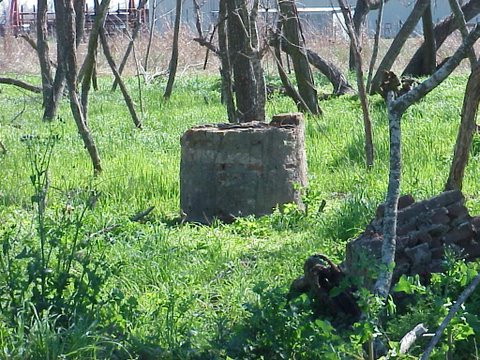
Photo: One of the few remnants of Pittsville, Texas – a cement cistern. It is located 50 yards from FM 359 behind the Historical Marker. Mjcs89, CC BY-SA 4.0 <https://creativecommons.org/licenses/by-sa/4.0>, via Wikimedia Commons
That is, in essence, how some towns disappear. Ghost towns aren’t always created through one dramatic disaster, but through a slow shift in where people travel, trade and build their lives.
2. Cane Island: The Name Before Katy
Cane Island is not a ghost town. It is the name beneath Katy’s name.
Long before Katy became Katy, the area was known as Cane Island. TSHA identifies Katy as “first known as Cane Island”, located where Harris, Waller and Fort Bend counties meet west of Houston. A Texas Historical Commission marker for the City of Katy adds that present-day Fifth Street follows the course of the old San Felipe Road, which was opened to Austin’s colony in the 1820s.
That same marker says Cane Island was known as a stagecoach stop before developers platted the Katy townsite after the Missouri, Kansas & Texas Railroad reached the area in 1895. The Katy post office opened in 1896, which is when “Katy” became the official community and post office name in a practical sense. Rice soon became one of the community’s defining industries.
The antiquated name “Cane Island” serves to remind us that Katy did not begin as a modern suburb or even as a polished small town. It began as prairie, road, rail, rice fields and a place travelers knew before most of today’s landmarks existed.
The city’s early years were not easy. The 1900 hurricane razed or damaged nearly every improvement in Katy except two houses, according to the Texas Historical Commission marker. But Katy rebuilt, and unlike many nearby communities, it kept growing. Katy finally became an incorporated city in 1945.
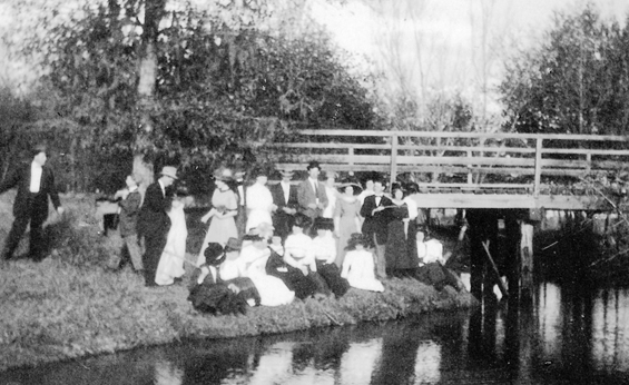
Photo: Katy Residents gather for a photo at Cane Island Creek Bridge in 1911. Via Carol Adams, Public domain, via Wikimedia Commons
Cane Island did not vanish the way Pittsville did. It transformed into Katy.
3. Addicks and Bear Creek: The Town Under the Reservoir
Addicks is still a familiar West Houston name, but the old community has mostly been divided up and hidden under a modern vocabulary: Highway 6, I-10, the Energy Corridor, Bear Creek Pioneers Park, Cullen Park and Addicks Reservoir.
The story began with Bear Creek. TSHA says Addicks originated as a railroad stop for the Bear Creek community, which had been established by German immigrants around 1850 along Bear, Langham and South Mayde creeks. Bear Creek residents had a one-room school near present-day Clay Road by 1876 and a post office by 1878.
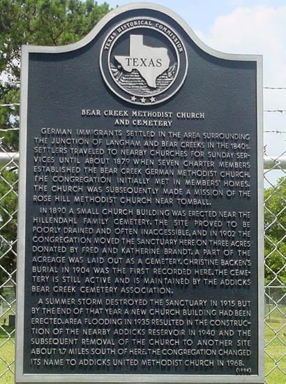
Image: Historical Marker for the Bear Creek Methodist Church and Cemetery in Addicks, TX. Image available on the Internet and included in accordance with Title 17 U.S.C. Section 107.
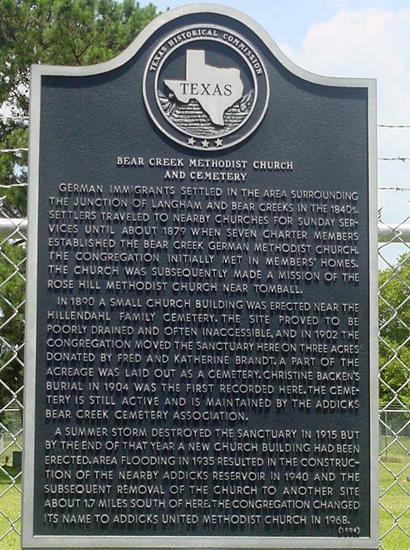
The community was surprisingly developed. The Bear Creek German Methodist Church, founded in 1879, and the Bear Creek Schuetzen Verein, a German shooting club, helped form the heart of local life. The shooting club hosted town meetings, dances, barbecues and traditional competitions.
Then the railroad shifted the center of the community south. Around 1893, William Schulz moved the Addicks post office and general store closer to the Missouri, Kansas & Texas Railroad depot near what is now Highway 6 and I-10. He laid out a townsite called Letitia, but the Addicks name stayed.
Disaster kept returning. The 1900 hurricane destroyed both Bear Creek and Addicks. The community rebuilt, only to be reshaped again in the 1940s when the federal flood-control project covered much of the townsite with water for Addicks Reservoir. By 1948, TSHA says 40 homes and buildings had been moved or destroyed.
The Addicks School graduated its last senior class in 1948. Addicks ISD later consolidated with Katy ISD in 1961. Houston annexed the reservoir area in 1972 and the areas around the old rail depot and townsite in 1992.
Addicks did not vanish into nothing, it vanished into modern infrastructure.
4. Barker: The Railroad Town Beneath West Houston’s Office Parks
Barker is another name many Katy and Houston-area residents recognize without knowing the town behind it.
TSHA places Barker on Interstate 10 in western Harris County, about 17 miles west of downtown Houston. In 1895, the Missouri, Kansas and Texas Railroad was operating through the community, which was named for track-laying contractor Ed Barker.
Early Barker had the bones of a town: an inn, a brick factory, a twine mill, a general store, a telephone company, a depot, two churches, a one-room public school and a saloon. By 1915, Barker’s population was 80, and rice farming, dairying and ranching were the chief occupations. Whole trainloads of cattle shipped out from Barker’s pens.
The modern contrast is almost hard to believe. TSHA notes that by the 1990s, multistory office buildings stood in Barker where rice still grew and cattle grazed in the 1970s. Within a twenty year span, the entire environment had shifted.
That shift occurred because West Houston moved toward it. Barker had already been tied to transportation since the Missouri, Kansas and Texas Railroad ran through the community in the 1890s. Later, as Interstate 10 became one of Houston’s major westward corridors, the same location that once made Barker useful for shipping cattle and farm goods made it valuable for offices, roads, subdivisions and commercial development.
In essence, Barker did not disappear because people stopped seeing value in the land. It disappeared because the land became valuable for something else. Rice fields became office sites. Cattle land became suburban growth. A railroad town became a name attached to roads, reservoirs and development.
5. Clodine: The Railroad Stop That Faded Into Fort Bend County
Clodine was never as large as Katy, but it had the features that made a small community feel permanent.
The community was established around 1888 as a station on the San Antonio and Aransas Pass Railway, about 12 miles northeast of Richmond and 21 miles southwest of Houston. It received a post office in 1893. By 1896, Clodine had a general store, a Baptist church and about 50 residents. A community school followed in 1897.
For nearby farm families, the railroad stop made Clodine a place to send and receive goods, collect mail, attend church, shop for supplies and gather around a shared local identity.

The town’s decline followed slowly. By 1914, the population had dropped to 25, though residents still had telephone and telegraph connections. Clodine’s numbers rose and fell in the years that followed, and the community remained useful because of surrounding farms and the Clodine oilfield. But in 1934, after the Texas and New Orleans Railroad bought the San Antonio and Aransas Pass line, the depot and section houses were removed. Without that railroad center, Clodine lost one of the main things that had made it a town instead of just a rural crossroads.
Even then, it did not disappear immediately. By 1947, Clodine was still described as a market and shipping point for surrounding farms and the nearby oilfield. What did fade was the old center of community life: the depot, the school-era identity and the small-town rhythm that had formed around the tracks.
6. Howellville: The Railroad Stop Houston Swallowed
Howellville is a name that will sound unfamiliar to most local residents. It was never large, but it had the pieces of a working rural community: a railroad stop, a post office, nearby farms and a name tied to the land.
According to TSHA, Howellville began as a station on the Texas and New Orleans Railroad south of Brays Bayou near the Fort Bend County line, about 10 miles southwest of Houston. It was named for T.E. Howell, who owned the townsite.
A post office operated there from 1920 to 1934. With help from area drainage work, the land supported dairying and farming, including corn and rice. From the 1920s through the 1990s, Howellville reported as many as two stores and a population of 36.
That is by no means a big town, but population count is not the metric that makes a community matter.
A post office meant people expected mail there. Stores indicated that families bought what they needed there. Farms and dairies meant work and routine.
But after the post office closed in 1934, Howellville became easier to overlook. It never grew beyond a small settlement, and as southwest Houston expanded, the old community was gradually absorbed into the surrounding city. What had once been a named railroad stop became part of a larger suburban map.
7. Gaston, Also Known as White’s Switch: The Fort Bend Stop That Fell Off the Map
Gaston is considered a true “lost community.” The community once sat in northwestern Fort Bend County and is remembered through its railroad history.
TSHA says Gaston, also known as White’s Switch, was a farming community on Farm Road 1093 about 10 miles north of Richmond. It was likely named for early settler Hudson Gaston, whose plantation was in the area.
The community was another settlement established in 1888 when the San Antonio and Aransas Pass Railway built through the area. Gaston’s post office opened in 1900 and closed in 1920. In 1914, while the community was still kicking, Gaston had a general store and was an important stop on the railway.
One interesting footnote gives Gaston a flicker of old Hollywood: the silent drama Western “North of 36” was filmed in the area in the early 1920s. The film follows a young woman who inherits a Texas ranch and leads a grueling 600-mile cattle drive to Kansas, a suitable plot for the quaint Western spot.
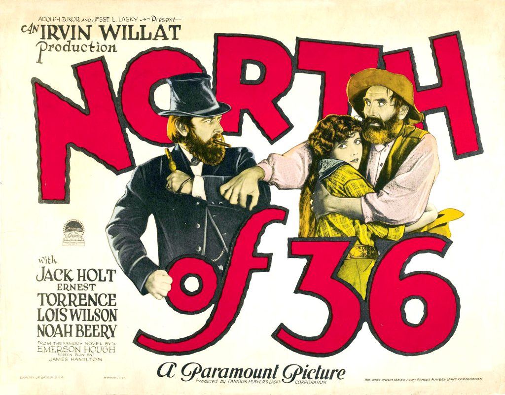
Photo: Paramount Pictures, Public domain, via Wikimedia Commons
Gaston was still identified on a county highway map in 1987, but the linked Texas Almanac data on TSHA’s entry now lists the place as no longer existing. That is a quiet ending for a community that once had a railroad stop, a post office, a store and a name residents expected to keep using.
8. Satsuma: The Citrus Town That Never Really Became a Town
Satsuma earned its spot on the broader West Houston list, especially for readers interested in forgotten towns beyond Katy’s immediate borders.
TSHA identifies Satsuma, also known as Ashford and Thompson Switch, as a site on U.S. 290 southeast of Cypress in northwestern Harris County. In 1910, J.T. Thompson, president of the Satsuma Land Company, platted a townsite on the Houston and Texas Central Railway and named it for the satsuma orange groves that were planned there.
The dream was bigger than the result.
A post office operated from 1909 to 1914, and by the time it closed, Satsuma had one general store. The site became a railroad shipping point, but TSHA says it “never developed as a town,” even after oil was discovered in the area in 1936.
By the 1980s, county maps still showed the townsite with Satsuma Chapel, an abandoned section house and a nearby pipeline pumping station.
Satsuma is not a classic ghost town. It is something more peculiar: a planned town whose name outlasted the town itself.
9. Cypress Top and Big Cypress: The Lost Pieces Inside Modern Cypress
Cypress is booming now, but the old Cypress area was not originally one neat town with one tidy beginning.
A Harris County historical marker says Cypress was “more a region than a single community”, covering more than 100 square miles in the Cypress Creek and Little Cypress Creek watersheds. Early settlements included Big Cypress, Hamblin, Eden, Cypress Grove, Cypress Top, Cypress City and the town of Cypress.
Big Cypress had a postmaster by 1840. The Cypress Top Post Office was established in 1851. In 1856, railroad tracks reached Cypress Top depot, 26 miles northwest of Houston, bringing stores, hotels and saloons.
That older world is not completely gone. Cypress Top Historic Park preserves a remnant of the railroad community, including historic structures tied to the area’s past.
Cypress is not lost in the manner Pittsville is lost. It is almost the polar opposite: the region grew so much that many of its smaller earlier identities disappeared inside the larger name.
10. Alief, Once Dairy Station: The Town That Reverted to Prairie Before Houston Took It In
Alief may feel far from Katy to readers who think in city-limit terms, but it belongs in the larger West Houston story because it shows how vulnerable these early prairie communities could be.
TSHA says Alief was originally known as Dairy and Dairy Station, located on Brays Bayou in western Harris County. The site was first settled in 1861, and by the 1890s a town was being platted. The name changed to Alief in honor of Alief Ozella Magee, the first postmistress.
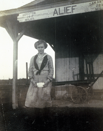
Then came a disaster that reshaped communities across the Gulf Coast. Alief suffered heavy damage in the flood of 1899 and the Galveston hurricane of 1900, which destroyed the Methodist Episcopal church and crops ready for harvest. When the railroad offered free transportation to residents who wanted to leave, many did.
TSHA says the town “reverted to prairie.” Only six of its 30 families and the Bassinger General Mercantile Store remained.
Alief later recovered, developed schools and businesses, and eventually became part of Houston. By the 1970s, much of the community had been annexed, though the Alief name remained. The railroad line that once ran through the community was later removed to make room for a toll road.
Alief is not a ghost town. But the old Dairy Station is gone, and that makes it part of the same story.
So, Why Did So Many Communities Disappear?
The lost communities around Katy did not all vanish for one particular reason.
Pittsville faded when the railroad bypassed it. Addicks was reshaped by hurricanes, flooding and the reservoir. Barker was overtaken by development. Clodine lost its depot and railroad center. Howellville lost its post office and faded into Houston’s expansion. Gaston’s railway stop and post office disappeared. Satsuma never fully became the citrus town its developers imagined. Alief was battered by flood and storm before becoming part of Houston.
However, an emergent pattern is clear. On the Katy Prairie and across greater Houston, towns survived when transportation, water, farming and commerce worked in their favor. They struggled when those forces moved somewhere else.
A post office could put a community on the map. A depot could make it matter. A school could keep families rooted. A church could give people a center. But if the railroad chose another route, or if floodwaters kept coming, or if a reservoir claimed the land or if suburban growth absorbed the region, a community could lose the aspects that rendered it a town.
Make no mistake, the ghosts are still here. The strangest thing about the ghost towns near Katy is that many of them are not empty at all. They are crowded. They sit beneath traffic, office buildings, subdivisions, school zones, parks, churches and highways. Their names still surface on maps and road signs. Addicks. Barker. Clodine. Cane Island. Satsuma. Bear Creek. Cypress Top. Pittsville.
Some were true ghost towns, while others were railroad stops or farming communities. Some were absorbed into Houston, Katy, Cypress or Fort Bend County growth. But all of them challenge the same assumption: that West Houston’s story began with master-planned neighborhoods and freeway exits.
It did not. Before Katy became Katy, the prairie already had names. And some of those names are still waiting to be remembered.